Trip to Ireland
Attendees: your correspondent (driver), the Austrian (navigator), Number One (second driver).
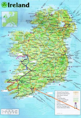
Route (click to enlarge):
Please take some time to look at this map because drawing the lines on took me ages.
Day One- Thursday 13 April 2006- London to Cork- orange line on the map (please refer)
We flew into Cork late in the evening and picked up the rental car which, oddly enough, we neglected to give a silly nickname, possibly because it was so late and we were all a bit tired. The Austrian looked away and then looked back all steely eyed and determined in what we would later call "GPS mode". He then navigated us to the Quality Hotel and Leisure Centre in a series of heavily accented but largely accurate commands, wincing only slightly when I drove through a red light. Speaking of Austrians in England, it was so late after we had had a bite to eat there wasn't much going on, so we retired to the hotel to watch "Arnold Schwarzenegger: Made in Britain", a vaguely absurd documentary about how the big fella really learned everything he knows pumping his guns in a dingy London basement during the 1960s. It reminded me of home grown claims to Phar Lap, Russell Crowe and various others who have only a passing affiliation with New Zealand who we nevertheless claim as our own, so it was quite comforting.
Number of leprechauns sighted: nil
Men in black suits trailing at a distance: two, sometimes three, depending on what we were saying.
Day two- Friday 14 April - Cork to Killarney- black line on the map (please refer, I beg you, please, it took me hours including instances of not saving it and having to start over)
We rose earliesh and drove a short way to Kinsale for breakfast. Kinsale is a very nice little harbour town which Lonely Planet Ireland (2006 ed) superlatively describes as "bursting with life and colour... with an extra seductive picture-postcard feel." Rick Stein visited once appparently and declared it the gourmet centre of Ireland. We did indeed take a very pleasant brunch at Cocina, I would link to it but it is that authentic it doesn't have a website.
From Kinsale we passed through Timoleague and stopped to investigate a derelict seventh centry abbey. Imagine our surprise when we came across some half naked Germans taking artistic photographs of each other in the ruins. "That's quite normal" declared the Austrian nonchalantly, partly out of regional loyalty, although I thought I caught him giving them a private reproving glance. Because it was such a bizarre scene I tried to photograph them myself through a hole in the wall, but they noticed and it all got quite weird, so we hoofed it.
From there we passed through Clonakilty and Skibbereen and then to the Mizen Head peninsula, the most south west part of Ireland. We went out to the observatory on said south western tip and declared it very good indeed. We met a salty old timer who told us he had fallen in love with a kiwi girl once, but who had broken his heart when she shacked up with a Frenchman. Perhaps she didn't like the cigarillos? He's heading out to New Zealand again this year, he didn't say why, perhaps it is in search of love.
From Mizen Head we charged up to Killarney, passing through Bantry and Kenmare. Once in Killarney we dined at Bricin, a country style restaurant which found favour. Number One and I tried the boxty, a traditional Irish dish which is kind of like stew wrapped in a crepe. Very useful at replacing concentration-calories lost while driving.
Leprechauns sighted- I thought I saw one but it was just a little Irish, so nil
Day Three- Saturday 15 April- Killarney to Dingle- red line on the map (if you haven't looked at the map yet, now's your chance)
Hearty Irish breakfast care of Maureen at the bed and breakfast and then a drive through Killarney National Park (lovely) on our way to the famous "Ring of Kerry" road route around the Iveragh Peninsula, starting from Kenmare (refer map). We passed through Sneem, and had the slowest produced coffee ever, and later Waterville for a Guiness recharge . Charlie Chaplin was apparently a Waterville regular. Refreshed, we headed out to Valentia Island (refer map). Number One had a snooze in the car while the Austrian and I went out on foot for a bit and in a different story the Austrian came to the brink of but returned from the Irish Afterlife, Guiness Island. Then a reasonably long drive around to the next pointy-outy bit, Dingle on the Dingle Peninsula. We listened to a fair amount of Irish radio, including a recurring story about how foreigners were disproportionately represented in fatal car accidents and also how the "Winter Vomiting Bug" seemed to be hitting harder than previous years. Oh how we laughed, what a silly name for an illness! More about that later.
Dingle is a small port town and home to Fungie the Dolphin who has been nudging small children out of the way of sharks and nudging boats off sand bars since 1984. We stayed up quite late listening to some Irish bands, pretending to know the words to various remixes of Whiskey in the Jar.
Day Four- Sunday 16 April- Dingle to Galway (you know, I can tell if people aren't looking at the map- it's coming down if it isn't used, and then none of this will make sense, so watch it)
Day Four was very much a driving day because we needed to cover quite a lot of distance to reach Galway in good time. However, we stopped at the famous Cliffs of Mohar, cliffs as high as two hundred metres over the Atlantic Ocean. Predictably populated by a lot of tourists such as ourselves, but still utterly breath taking, wonderful and well worth it. Refer photos below.
Reached Galway by the evening and had a gourmet meal at the Druid Lane Restaurant. The Austrian asked for a Guiness and was sharply informed that it was a wine bar, so it was bottle beers only, thank you very much. Polite as ever, he demurred without pointing out the logical flaw in this statement. The meal, however, was spectacular, if you are ever in Galway and feel like a treat this is the right place.
Day Five- Monday 17 April- Inish Moor, Aran Islands
A day trip out to Inish Moor, one of the three islands making up the Aran Islands. It is only a short trip from Galway, so oft visited by tourists, and according to the guide book during July/ August your best bet is going to the slightly more remote Inishmaan or Inisheer islands. Almost the entire island is covered with by a network of stone walls on a very barren almost moon like landscape, which looks quite remarkable (refer photographs below). Number One observed that some of these fields appear to contain only rocks, and we spent a lot of time pontificating on how that came to be. We hired bicycles and rode the length of the island across to Dun Aongusa fort. It didn't look far on the map, only about four miles, but of course the map didn't account for the massive hills and strong head winds! So it actually took us a fair while, with some walking thrown in. It was well worth it, however, Dun Aonghasa is amazing. It is a bronze age fort believe to have been constructed around 2000 years ago and is in remarkably good shape. It is on a cliff top to command views of potential attackers and still surrounded by "chevaux de frise", an arrangement of defensive stone spikes designed to make slow them down if they even make as far as the fort itself. The view is just wonderful and you can just imagine bronze age discussions about how the value would sky rocket in centuries to come.
Day Six- Tuesday 18 April- Galway
Winter Vomiting Bug.


2 Comments:
I took considerable time looking at the map, staring at your line. Its beautiful.
My nephew and niece are in the environs of Galway right now, so shall stare at the map some more. Then I will find my wife and read the entry together.
And thanks.
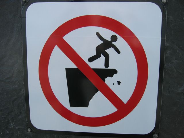
Most instructive and entertaining, especially the detailed research on signage, but a pity about the lack of leprachauns.
Mum
Post a Comment
<< Home